History: The area between Nordegg and Banff Park has been popular with First Nations for thousands of years for hunting, spiritual activities and access across the mountains.
The first European fur traders and explorers (including David Thompson) passed through this area early in the 19th century in their quest for a passage over the Rocky Mountains to the Pacific Coast and what is now British Columbia.
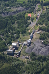
The town of Nordegg owes its existence to the discovery of coal in the region by German immigrant Martin Nordegg, who founded the Brazeau Coal Mine in 1911. Between that time and 1955, when the mine shut down, the community of at times up to 3'000 people was based on the mining operation, which provided coal to the rapidly expanding railway network in the West. The switch to diesel fuel resulted in the closure of the mine and the town was subsequently demolished.
Today, Nordegg counts just over 100 permanent residents and acts as a gateway to the West Country, also known as Bighorn Country. The forested hills to the east, north and south of the hamlet are heavily impacted by oil & gas and forestry operations; towards the west, as you move into the front ranges of the Rockies, it is still virtually undeveloped.
The scenery here is comparable to that in adjacent Banff and Jasper National Parks - without the crowds and rampant tourism development found in the National Parks. Visitors to Nordegg will find basic services here, before heading into the surrounding region for a true back-country / wilderness experience: a motel/restaurant, cabin rentals, campground, an HI hostel, gas station, convenience store, liquor store, post office and a quaint mine museum /souvenir store / country cafe which is open in the summer season only.
Activities: Apart from the highly recommended guided mine tours available
from mid May to early September (check-in at the museum http://www.nordegghistoricalsociety.org/index.html ), activities are mostly
outdoor / nature based: hiking, fishing, trail riding, camping, mountaineering, cycling, canoeing in summer and winter hiking, snowshoeing, X-country skiing, ice-climbing in winter. If you are not into the mechanised recreational activities (ATV's and snowmobiles), you are advised to spend most of your time closer to the Parks, west of the Bighorn Dam, where these activities are not allowed.
There are many hiking trails in the region but most are not maintained and are unmarked. Your best resource is The David Thompson Highway: A Hiking Guide, by Jane Ross and Daniel Kyba, which is also a superb source of historic, geographical and natural history information for the area between Nordegg and Banff National Park.
Attractions: Again, other than the mine tours in Nordegg, the Bighorn Dam /
Power Station and some historic / native sites, most area attractions are
natural. Many are accessible by vehicle but even more require anywhere
between a half hour walk to multi-day back-country hikes. However, Hwy 11 between Nordegg and Saskatchewan Crossing alone counts as one of the most scenic roads in North America with views that rival those found in the
mountain parks. There are numerous lakes (Abraham, Fish, Goldeye, Peppers Lake), rivers (North Saskatchewan, Bighorn, Cline, Siffleur, Blackstone, North and South Ram Rivers), waterfalls (Ram, Crescent, Siffleur Falls), Canyons (Bighorn, Cline, Ram River), ridge walks and forest trails worth exploring.
Abraham Lake, at 33km long, is Alberta's longest man made lake,
but at the height of summer and fall, it's turquoise waters offer some of
the most stunning panoramic views in the Rockies. Wildlife is fairly
abundant in this region too and finds a refuge in the Kootenay Plains
Ecological Reserve upstream of the lake. Unfortunately, hunting and trapping are reducing the numbers and you will not encounter the majestic bull elk or bighorn sheep rams you can see in the National Park, where they are protected.
Access: Nordegg can be reached from Red Deer / Rocky Mountain House to the east (1-2 hr drive respectively), or Saskatchewan River Crossing in Banff
National Park to the west (1 hr drive). The Forestry Trunk Road is an
unpaved resource road, which runs north - south from Edson (on Hwy 16 -
Yellowhead Hwy) to the Bow Valley Parkway (Hwy 1a) near Cochrane.
Whereas Hwy 11 is an excellent, well maintained, paved all-season road, travel on the winding and unpaved Forestry Trunk Road is not recommended (or even impossible) in the winter season or after severe summer storms (high ground clearance / AWD recommended. If you rent a vehicle, note that many rental contracts do not allow you to travel on this and other gravel roads).

Aurum Lodge and cottage: close to nature - far from the crowds

Dig up the past in historic Nordegg